A lesson in sharing the road
Courtesy of the San Diego County Bicycle Coalition

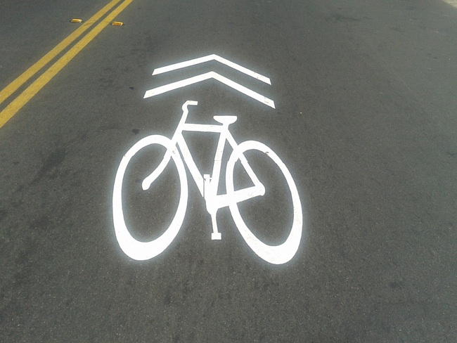
What are Sharrows?
Sharrows, shorthand for Shared Lane Markings, are state-approved, forty-inch-wide, white bicycle images with two forward pointing arrows painted on some streets.
Where are Sharrows?
• Sharrows are painted on streets primarily where a travel lane is too narrow for side-by-side sharing – too narrow for motorists to safely drive next to bicyclists within the same lane.
• Sharrows were recently installed all the way down 30th Street, from Normal Heights into Golden Hill, in advance of CicloSDias and can now also be found in Encinitas, Leucadia, Solana Beach, and Oceanside in North County, as well as the San Diego communities of Ocean Beach, Point Loma, and Downtown. As need arises sharrows will be used in more places.
Why are there Sharrows?
• Sharrows recommend where it is generally safest for bicyclists to ride, positioned toward the middle of a lane. This position reminds bicyclists to ride far enough away from parked vehicles to avoid being struck by suddenly opened car doors.
• Sharrows also guide bicyclists toward the center of the lane to discourage unsafe passing within the same lane by motor vehicles.
• Sharrows serve to alert motorists that bicyclists may be using the full travel lane. To pass a bicyclist who is using a full lane or a lane with sharrows, a motorist should wait for a safe opportunity to move entirely into an adjacent lane.
• Additionally, “Bicycles May Use Full Lane” signs remind all of us that people have the right to use the full travel lane, using a bicycle or a vehicle.
 What is a Bike Lane?
A Bike Lane is a part of a roadway marked by a solid white line and frequent bicycle symbols and arrows painted along many streets. Bike Lanes are usually accompanied by “Bike Lane” signs.
Where are Bike Lanes?
Bike Lanes are usually to the right of travel lanes, but sometimes between the rightmost through-only lane and a right-turn-only lane.
How should we use Bike Lanes?
- Vehicles may not normally be driven or parked in Bike Lanes, however, motorists are to yield to bicyclists before entering or making a turn across a Bike Lane.
- Bicyclists must normally use a Bike Lane when traveling slower than other traffic, but may leave the Bike Lane to avoid hazards such as to get away from the right hook zone, when approaching an intersection with a road, alley or driveway, or to prepare for a left turn.
- Bicyclists must yield to overtaking traffic in the next lane before leaving the Bike Lane.
- Bike Lanes are dashed or terminated before intersections so that bicyclists and motorists are reminded to merge into the appropriate lanes and lane positions for their respective destinations.
Ride and share safely!
For more information about the San Diego County Bicycle Coalition, visit sdcbc.org.
Regional transportation plan needs rework
By Jack Shu, president
Cleveland National Forest Foundation
For anyone who has traveled to other modern cities whether in the United States or abroad, they would know that San Diego rates poorly when it comes to having an effective transit system. This hurts our region’s economy and our health.
As we grow with more residents and jobs Downtown, any delay in developing a vital transit system will only increase its cost. Yet the SANDAG board, consisting of our political leaders and who is responsible for regional transportation planning, are continuing to invest most of our tax dollars on additional freeway lanes. Such a policy will only give us traffic relief for a few years, not to mention that we don’t have parking spaces for all the cars that these roads will bring to the city. We know this because we, along with other cities, have and are experiencing it.
Transit experts know that a light rail system connecting all our city centers has the capacity we need to make major transit routes work far better than bus lines.
When there is a Padres game or a major event at Qualcomm, what’s the transit system that is helping most people get there without driving? Trolley lines, not buses.
Cities throughout the world are investing in rail and abandoning failed Bus Rapid Transit (BRT) lines for major routes. SANDAG’s own Urban Transit Strategy also calls for more rail lines; only their plan does not have them completed until 2040 or 2050.
In the next few weeks and months, SANDAG plans to commit billions of dollars implementing its 2050 Regional Transportation Plan. This is a plan which has been ruled a planning failure by the Superior Court. The plan calls for substantial expenditures on expanded freeway/BRT systems which will ultimately clog our Downtown communities with buses – starting next year – without delivering a real mobility answer to commuters, businesses and pedestrians.
It’s time to stop investing in a system that no longer meets the mobility challenges of a changing economic and social world. Since we don’t produce gas or cars in San Diego, additional auto commuters will cause more capital to leave our region.
On the other hand, investment in an effective transit network that connects our region’s urban centers will provide real economic returns for Downtown businesses as well as improve the quality of life for everyone in the region. At the very least, our elected officials who govern SANDAG need to assess more viable alternatives.
Residents, restaurant owners, retailers and anyone who works in Downtown need to get involved now. Regardless of which city you live in, contact your mayor and city councilmember and ask what their position is on upcoming transportation projects. Ask them if they will stop these projects so that better investments in our transportation systems can be considered and implemented.
Act now so that we can have a vibrant San Diego.
The Urban Transit Strategy can be found at: sandag.org
Information comparing light rail to BRT and the economic benefits of transit development can be found at: transitsandiego.org


