Uptown organizations prepare to accommodate SANDAG bike corridor
Por Hutton Marshall | Editor SDUNLast fall, the San Diego Association of Governments (SANDAG) approved the largest bicycle infrastructure plan San Diego County ever saw. Its board of directors voted to allocate $200 million toward creating bicycle corridors, paths, lanes and racks throughout San Diego, creating a bicycle-friendly landscape meant to encourage San Diegans to get out of their cars.

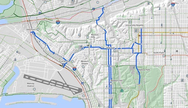
With sections of the corridor slated to begin in 2016, Uptown and North Park are near the top of the list as “high-priority projects.” They are also among the largest portions of the citywide project. Uptown’s plan alone will cost over $43 million, according to a SANDAG analysis done last year.
Some in the area have expressed concern regarding how this large investment could impact existing infrastructure, such as already congested thoroughfares and highly impacted parking. Where the corridor is planned to run through downtown Hillcrest on University Avenue, which is currently lined with metered parking, Hillcrest business owners have publicly questioned whether the planned route will do more harm than good.
At a recent Hillcrest Business Association board of directors meeting, several attendees expressed a desire for the corridor to reroute up to Washington Street through Hillcrest — a possibility several HBA members have also supported — saying this would impact fewer storefronts and parking spots. HBA Board President Johnathan Hale stressed compromise and cooperation, resulting in the HBA creating an ad-hoc committee to look at different aspects of the bike corridor, and how it might impact Hillcrest business.
Loss of revenue from metered parking has been a common concern of the route through University Avenue. There are 126 metered spaces along the planned route for the bicycle corridor, according to Elizabeth Hannon, the chief operating officer of the Uptown Community Parking District. SANDAG previously estimated that the route could necessitate the removal of 91 metered spaces through the area, which could result in a loss of over $40,000 for the parking district, according to an estimate it did in 2013.
That is a “worst case” scenario, stressed Hannon, who is actively working with SANDAG to mitigate parking loss. SANDAG active transportation planner Beth Robrahn stressed that the estimate of 91 parking spaces lost was very preliminary, but also stated a more updated figure was not yet available. Regardless, Hannon said, Hillcrest is already a highly impacted parking area, meaning a lot of demand and not enough supply, so many options already being explored are now being looked at more seriously. Hannon said she expects a new figure from SANDAG in June.
When asked if she would advocate for moving the corridor from University Avenue up to Washington Street, Hannon, like the HBA, refrained from vocalizing a black-and-white position.
“We’re working to understand their alignment choices,” Hannon said, adding that developing alternative parking strategies in Hillcrest is imperative. “We’re looking to work with SANDAG andtheir resources to help us implement any projects that would change the way parking is utilized in Hillcrest.”
Robrahn said that the idea of moving the route up to Washington Street was unrealistic. Not only has significant research and planning already taken place with the University Avenue route, but also a bicycle corridor on Washington Avenue would pose difficult design challenges, namely, accommodating both a bicycle corridor and an onramp for Highway 163. Robrahn said SANDAG is now focused on developing a comprehensive, fleshed-out plan that is cohesive with the community,and will look at employees using parking lots, parking validation strategies, and smart meters.
While neither the HBA nor the parking district has formally opposed the current route, SANDAG will be required to undergo a review, inspection and approval process by the City once the planning portion of the project is complete. This was part of a formal agreement between the City and SANDAG in 2009, due to the large number of SANDAG projects that impact City infrastructure, said a spokesperson in the mayor’s office through email.
“This is a binding contract, and SANDAG has to comply, especially when building a project such as the Uptown Bike Corridor that will be entirely owned and maintained by the City,” the spokesperson stated.
Robrahn said that SANDAG has interacted with the City’s Planning and Developmental Service departments throughout the process.
“Street Diet” project
Although it may be relatively small in comparison, the City has bike lanes of its own nearing implementation much sooner than the SANDAG corridor. One lane will be removed from both Fourth and Fifth avenues to create protected bikeways in either direction. This was scheduled to be implemented earlier this year, but was pushed back to April or May to allow for more community outreach, said a spokesperson for Council President Todd Gloria.
The different variations of bikeways
There are four commonly seen types of bikeways in San Diego, each offering a different degree of protection from traffic.
The first is a bike sharrow, or shared-lane markings. The most cost effective in terms of implementation, bike sharrows are the white bicycle and arrows painted onto the street. This indicates to drivers and cyclists that the road is to be shared.
The second is the bike lane. This is a separate lane between traffic and parked cars indicated by two parallel white lines.
The third is the protected bike lane. It’s the same as a bike lane, but with an added buffer space between the bike lane and traffic, or between the bike lane and parked cars.
The fourth is the bike corridor, or segregated bike path, which is what will go along University Avenue. Here, the cyclists are completely separated from traffic, often by a physical barrier. If there is parking on a street with a bike corridor, it is between the cyclists and the traffic.


